Opiki Toll Bridge
A History
Home
|
In the late 1800s, the idea of creating new farmland alongside the Manawatu River lead to an attempt to drain the swamplands. Farming was delayed but the drainage coincidentally created perfect conditions for growing flax, which prompted the building of numerous flax mills. With the flax being on the opposite side of the bridge to Palmerston North, flax millers had a hard time transporting flax across the river to the railway. With the rapid growth of the flax industry, this soon became a major problem, with only one solution. Thus the Opiki Bridge was born. This website gives a brief history of the life of the Opiki Suspension Bridge, from the draining of the Makurerua Swamp, through the swamp's flax industry, the construction of the bridge, its conversion to a toll bridge, to the closing of the old toll bridge and the opening of the new bridge at Opiki.
Next: "The Beginning"
|
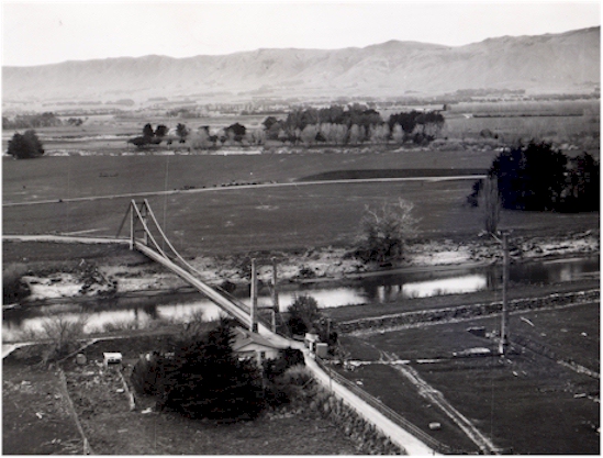 This photo taken in September 1969 looks towards Palmerston with the Tararua Ranges in the background. The Opiki Toll Bridge and tollhouse can be seen in the middle. The remains of the 'Tane' mill chimney can be seen on the right.
Last update: Friday, September 26, 2003 at 4:13:07 PM.